Tropical Storm Erin is on track to become the first major hurricane of the 2025 Atlantic season. Here’s what’s driving its growth, where it could go, and how to prepare.

The Atlantic hurricane season is heating up, and all eyes are now on Tropical Storm Erin. Formed over the warm waters of the eastern Atlantic, Erin is already showing signs of steady intensification — with forecasters predicting that it could become the season’s first major hurricane by this weekend. While its exact track remains uncertain, the storm’s development is a reminder that we are entering the most active part of the hurricane season, when warm seas and favorable atmospheric conditions can fuel rapid cyclonic growth.
Current Status: Where Erin Is Now
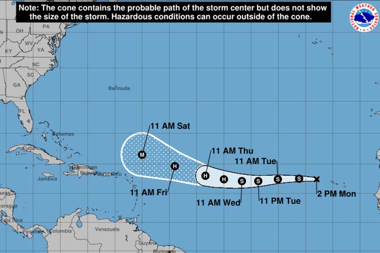
As of early Monday morning, Erin was located about 280 miles west-northwest of the Cabo Verde Islands and roughly 2,300 miles east of the Leeward Islands. Sustained winds were near 45 mph, and the storm was moving westward at about 20 mph.
The National Hurricane Center (NHC) expects Erin to continue on this westward track for the next couple of days before potentially turning northwest later in the week. This shift in direction will play a major role in determining which land areas, if any, face direct impacts.
The Forecast: Slow But Steady Intensification
Meteorologists predict Erin will strengthen gradually over the next several days. The warm waters of the tropical Atlantic — currently experiencing above-average sea surface temperatures — are providing ample fuel for the storm.
By midweek, Erin is forecast to reach Category 1 hurricane strength (sustained winds of at least 74 mph). By the weekend, conditions could allow Erin to intensify further into a Category 3 hurricane or higher, with winds exceeding 111 mph.
The primary drivers behind this forecast include:
- High ocean heat content: Sea surface temperatures in Erin’s path are above 82°F (28°C), which significantly aids storm growth.
- Low wind shear: Minimal disruption in upper-level winds allows the storm to maintain a strong, organized core.
- Ample moisture: A humid atmosphere helps maintain intense thunderstorms around the storm’s center.
The Possible Track: Too Soon to Call
While long-range models suggest a northward turn later this week, exact landfall predictions are premature. Current consensus indicates:
- Low threat to the Caribbean if the storm curves early enough.
- Possible Bermuda impact if Erin continues further west before turning north.
- Reduced risk to the U.S. East Coast — but not zero, as late shifts in track are common.
The National Hurricane Center stresses that five-day forecasts can still be off by hundreds of miles, meaning residents from the Caribbean to the Eastern Seaboard should monitor updates closely.
Why Erin Is Getting Strong So Quickly
One major factor in Erin’s expected rapid growth is the ongoing marine heat wave in the Atlantic. Record-warm waters not only fuel hurricanes but can also help them intensify much faster than average.
This season’s climate setup features:
- A strong West African monsoon producing vigorous tropical waves.
- A weakening La Niña pattern, which often reduces Atlantic wind shear.
- Persistent high-pressure systems steering storms westward before they curve north.
These elements combined create ideal breeding grounds for strong hurricanes.
The 2025 Hurricane Season So Far
Tropical Storm Erin is the fifth named storm of the 2025 Atlantic hurricane season. While previous storms this year have been relatively weak or short-lived, Erin marks the first system with a high likelihood of becoming a major hurricane.
Hurricane experts note that activity typically peaks between mid-August and late September. Statistically, some of the strongest and most damaging storms on record have formed during this window.
Preparedness Tips for Coastal Residents
Even if Erin never makes landfall in the U.S., its development is a timely reminder for coastal residents to review emergency plans:
- Know your evacuation routes and shelter locations.
- Stock up on essentials: water, non-perishable food, medications, batteries, and flashlights.
- Secure outdoor items to prevent damage from strong winds.
- Check your insurance coverage for flood and wind damage.
- Stay informed by following official NHC updates and local emergency management alerts.
Economic and Travel Considerations
Major hurricanes don’t just threaten lives and property — they can also disrupt travel, trade, and tourism. Airlines and cruise operators are already monitoring Erin’s path for possible schedule changes.
In past hurricane seasons, even storms that stayed offshore have caused:
- Cruise itinerary adjustments in the Caribbean and Bermuda.
- Flight cancellations due to airport closures or high winds.
- Shipping delays as vessels reroute around dangerous seas.
Travelers planning trips to the Caribbean or Bermuda in the coming week should monitor developments closely.
Environmental Impact
If Erin intensifies into a major hurricane, it could have significant ecological effects:
- Coral reef damage from strong waves and shifting sediments.
- Coastal erosion on vulnerable islands.
- Storm surge flooding impacting mangrove systems and wetland habitats.
Scientists are increasingly studying how climate change may be fueling stronger hurricanes, with warmer oceans providing more energy and increasing the potential for rapid intensification events like Erin.
Social Media’s Role in Storm Awareness
As with politics, extreme weather events are now heavily discussed — and sometimes debated — on social media platforms.
During storms like Erin, posts with real-time radar, satellite images, and model runs spread quickly. While these can be useful, misinformation can also circulate rapidly. Meteorologists urge the public to rely on official sources like:
- National Hurricane Center (NHC)
- National Weather Service (NWS)
- Local emergency management agencies
What to Watch in the Coming Days
- Intensity Trends – Will Erin follow the forecasted steady growth, or will we see rapid intensification into a major hurricane sooner than expected?
- Track Shift Potential – Small changes in steering winds could dramatically alter the path and potential land impacts.
- Interaction with Other Systems – Additional tropical waves are following Erin; these could compete for energy or alter atmospheric patterns.
- Public Response – Early preparedness versus last-minute rushes to act could affect outcomes if the storm threatens populated areas.
The Bigger Picture
Erin is a reminder of the increasing volatility of the Atlantic hurricane season. Even if the storm spares major landfalls, the conditions producing it are a warning sign: warm oceans and favorable weather patterns are combining to make powerful storms more likely.
For Americans along the East Coast and in island territories, the takeaway is simple: don’t let your guard down. Hurricane season still has months to go, and Erin could be just the beginning of a busy late summer.
Final Thought:
While it’s too soon to say if Tropical Storm Erin will directly impact the U.S., the storm’s steady march toward major hurricane status is a clear signal that the Atlantic is entering its most dangerous period of the year. Whether you’re in Florida, the Carolinas, New England, or planning a trip to the Caribbean, stay informed, stay prepared, and treat every storm forecast with the seriousness it deserves.